-
Faculty of Arts and HumanitiesJakobi 2, r 116-121, 51005 Tartu linn, Tartu linn, TartumaaJakobi 2, 51005 Tartu linn, Tartu linn, TartumaaJakobi 2, IV korrus, 51005 Tartu linn, Tartu linn, TartumaaJakobi 2, III korrus, ruumid 302-337, 51005 Tartu linn, Tartu linn, TartumaaÜlikooli 16, 51003 Tartu linn, Tartu linn, TartumaaÜlikooli 18, 50090 Tartu linn, Tartu linn, TartumaaLossi 3, 51003 Tartu linn, Tartu linn, TartumaaPosti 1, 71004 Viljandi linn, ViljandimaaJakobi 2, 51005 Tartu linn, Tartu linn, TartumaaJakobi 2, 51005 Tartu linn, Tartu linn, TartumaaFaculty of Social SciencesLossi 36, 51003 Tartu linn, Tartu linn, TartumaaJakobi 5, 51005 Tartu linn, Tartu linn, TartumaaLossi 36, ruum 301, 51003 Tartu linn, Tartu linn, TartumaaNarva mnt 18, 51009 Tartu linn, Tartu linn, TartumaaNäituse 2, 50409 Tartu linn, Tartu linn, TartumaaNäituse 20 - 118, 50409 Tartu linn, Tartu linn, TartumaaLossi 36, 51003 Tartu linn, Tartu linn, TartumaaRaekoja plats 2, 20307 Narva linn, Ida-VirumaaLossi 36, 51003 Tartu linn, Tartu linn, TartumaaLossi 36, 51003 Tartu linn, Tartu linn, TartumaaFaculty of MedicineRavila 19, 50411 Tartu linn, Tartu linn, TartumaaBiomeedikum, Ravila 19, 50411 Tartu linn, Tartu linn, TartumaaNooruse 1, 50411 Tartu linn, Tartu linn, TartumaaL. Puusepa 1a, 50406 Tartu linn, Tartu linn, TartumaaL. Puusepa 8, 50406 Tartu linn, Tartu linn, TartumaaRavila 19, 50411 Tartu linn, Tartu linn, TartumaaUjula 4, 51008 Tartu linn, Tartu linn, TartumaaRavila, 50411 Tartu linn, Tartu linn, TartumaaRavila 19, 50411 Tartu linn, Tartu linn, TartumaaFaculty of Science and TechnologyVanemuise 46 - 208, 51003 Tartu linn, Tartu linn, TartumaaNarva mnt 18, 51009 Tartu linn, Tartu linn, TartumaaRavila 14a, 50411 Tartu linn, Tartu linn, TartumaaNarva mnt 18, 51009 Tartu linn, Tartu linn, TartumaaRiia 23, 23b - 134, 51010 Tartu linn, Tartu linn, TartumaaNooruse 1, 50411 Tartu linn, Tartu linn, TartumaaJ. Liivi tn 2, 50409 Tartu linn, Tartu linn, TartumaaRiia 23b/2, 51010 Tartu linn, Tartu linn, TartumaaVanemuise 46, 51003 Tartu linn, Tartu linn, TartumaaVanemuise 46, 51003 Tartu linn, Tartu linn, TartumaaArea of RectorArea of Vice Rector for Academic AffairsUppsala 10, 51003 Tartu linn, Tartu linn, TartumaaÜlikooli 18b, 51005 Tartu linn, Tartu linn, TartumaaÜlikooli 18a (III korrus), 51005 Tartu linn, Tartu linn, TartumaaArea of Vice Rector for ResearchW. Struve 1, 50091 Tartu linn, Tartu linn, TartumaaArea of Director of AdministrationÜlikooli 18, ruumid 102, 104, 209, 210, 50090 Tartu linn, Tartu linn, TartumaaÜlikooli 18A (III korrus), 51005 Tartu linn, Tartu linn, TartumaaArea of Head of FinanceÜlikooli 17, 51005 Tartu linn, Tartu linn, TartumaaArea of Vice Rector for DevelopmentLossi 25, 51003 Tartu linn, Tartu linn, TartumaaVanemuise 46, 51003 Tartu linn, Tartu linn, TartumaaNarva mnt 18, 51009 Tartu linn, Tartu linn, TartumaaArea of Academic SecretaryUppsala 6, Lossi 36, 51003 Tartu linn, Tartu linn, Tartumaa
Information system SATIKAS helps to detect mowing by using satellite data
In the publication ”The Ever Growing Use of Copernicus across Europe’s Regions” published at the end of last year, 99 success stories that have come true due to the Copernicus programme are stated. The story chosen from Estonia is about SATIKAS which detects all mowing on agricultural grasslands in Estonia and has been developed by the UT Tartu Observatory, the Estonian Agricultural Registers and Information Board (ARIB), and CGI.
SATIKAS is an automated satellite based information system. The goal of the project is to automate the EU’s agricultural subsidy checks – this will help to decrease and replace the inspectors’ field visits. "Given the rising labour costs in Europe it is very reasonable," said Kaupo Voormansik, Research Fellow at the Remote Sensing Department of the UT Tartu Observatory. Besides saving money and time, the system also works as a reminder to the farmers who have not yet fulfilled the mowing requirements.
Cloudy sky is not an obstacle
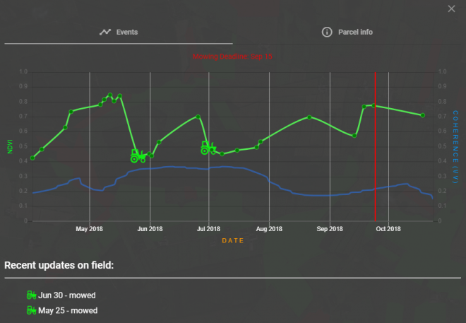
Mowing and the range of it can be observed from sudden changes in the biomass levels in the time series parameters of the satellite data. The original satellite pictures are converted into a number of processed data layers – also pictures by nature. After that, the average value is calculated of each date’s picture and each grassland. This is how the time series is formed. Afterwards, a deep learning algorithm is used on the time series for detecting the mowing information. The information received from SATIKAS will then move into the information systems of ARIB.
In the spring and early summer, a lot of data can be added to the time series: in 2018, a new picture could be taken even more often than once a week. Towards autumn, however, the weather gets cloudier and optical measurements cannot be relied on as much. "In August and September, there can be month or month-and-a-half long gaps in the time series of the optical pictures (Sentinel-2) due to clouds. The radar data from Sentinel-1 offers a good chance of filling those gaps," Voormansik described. Thanks to a longer wavelength, the impulses of Sentinel-1 penetrate clouds easily and there is enough data regardless the weather – four pictures per six days.
The observatory developed the engine for data processing
Out of all the researchers at the observatory, the radar remote sensing work group have been working on SATIKAS the most. The observatory’s role in the project has been doing applied research and developing the engine for data processing.
"The preparatory research actually started in the spring of 2011 when I was a PhD student at the University of Tartu. From the research that was being done in the course of the PhD thesis we gradually got to the SATIKAS project," Voormansik said. The contracting entity of the project is ARIB and the task of the IT and business service enterprise CGI has been to pre-process the satellite pictures and to integrate the data into the current ARIB information systems. Soon the CGI server will be replaced with a national mirror site called ESTHub.
Transparency is crucial
By now, SATIKAS has an algorithm that works accurately in most cases and a well-functioning processing chain. “Clear mowing can be detected well, we still have some problems with partial mowing, herding, and other exceptional cases where the algorithm can go wrong,” Voormansik stated. The goal is to distinguish these exceptional cases that cause mistakes and stabilize the processing chain.
After that, they will start exploring new checks that could be automated with satellite remote sensing. “Our work can be considered done when all of the agricultural checks that could be done with remote sensing are finished,” Voormansik said. In his opinion, this will take five to ten years.
Voormansik added that in the development process, it has to be kept in mind that transparency is extremely important. Both the primary data and results of data processing have to be shared with farmers. Supposedly, the data can be viewed on the ARIB web map in the summer of this year.
The publication "The Ever Growing Use of Copernicus across Europe’s Regions" can be read online. The SATIKAS story starts on page 58.
The European Regional Development Fund finances 85% of the ARIB project "Detection of mowing events with satellite-based monitoring" costs, 15% of the costs are covered by national co-financing.
Read more similar news